


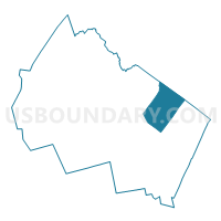
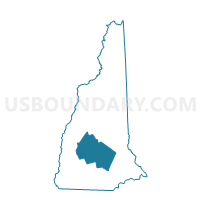
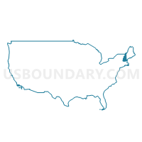
TOWN OF LOUDON Voting District, Merrimack County, New Hampshire
About
Outline

Summary
| Unique Area Identifier | 616391 |
| Name | TOWN OF LOUDON Voting District |
| County | Merrimack County |
| State | New Hampshire |
| Area (square miles) | 47.44 |
| Land Area (square miles) | 46.79 |
| Water Area (square miles) | 0.64 |
| % of Land Area | 98.64 |
| % of Water Area | 1.36 |
| Latitude of the Internal Point | 43.31269210 |
| Longtitude of the Internal Point | -71.44035570 |
Maps
Graphs
Select a template below for downloading or customizing gragh for TOWN OF LOUDON Voting District, Merrimack County, New Hampshire


Neighbors
Neighoring Voting District (by Name) Neighboring Voting District on the Map
- CONCORD WARD 10, Merrimack County, NH
- TOWN OF BARNSTEAD Voting District, Belknap County, NH
- TOWN OF CANTERBURY Voting District, Merrimack County, NH
- TOWN OF CHICHESTER Voting District, Merrimack County, NH
- TOWN OF GILMANTON Voting District, Belknap County, NH
- TOWN OF PEMBROKE Voting District, Merrimack County, NH
- TOWN OF PITTSFIELD Voting District, Merrimack County, NH
Top 10 Neighboring County Subdivision (by Population) Neighboring County Subdivision on the Map
- Concord city, Merrimack County, NH (42,695)
- Pembroke town, Merrimack County, NH (7,115)
- Loudon town, Merrimack County, NH (5,317)
- Barnstead town, Belknap County, NH (4,593)
- Pittsfield town, Merrimack County, NH (4,106)
- Gilmanton town, Belknap County, NH (3,777)
- Chichester town, Merrimack County, NH (2,523)
- Canterbury town, Merrimack County, NH (2,352)
Top 10 Neighboring Place (by Population) Neighboring Place on the Map
Top 10 Neighboring Elementary School District (by Population) Neighboring Elementary School District on the Map
- Barnstead School District, NH (4,593)
- Gilmanton School District, NH (3,777)
- Chichester School District, NH (2,523)
Top 10 Neighboring Secondary School District (by Population) Neighboring Secondary School District on the Map
Top 10 Neighboring Unified School District (by Population) Neighboring Unified School District on the Map
- Concord School District, NH (37,824)
- Merrimack Valley School District, NH (17,407)
- Shaker Regional School District, NH (9,708)
- Pembroke School District, NH (7,115)
- Pittsfield School District, NH (4,106)
Top 10 Neighboring State Legislative District Lower Chamber (by Population) Neighboring State Legislative District Lower Chamber on the Map
- State House District 5, Belknap County, NH (24,325)
- State House District 6, Merrimack County, NH (20,216)
- State House District 11, Merrimack County, NH (17,306)
- State House District 8, Merrimack County, NH (12,994)
- State House District 7, Merrimack County, NH (9,638)
- State House District 6, Belknap County, NH (3,777)
Top 10 Neighboring State Legislative District Upper Chamber (by Population) Neighboring State Legislative District Upper Chamber on the Map
- State Senate District 17, NH (58,086)
- State Senate District 15, NH (55,399)
- State Senate District 7, NH (54,987)
- State Senate District 4, NH (54,249)
Top 10 Neighboring 111th Congressional District (by Population) Neighboring 111th Congressional District on the Map
Top 10 Neighboring Census Tract (by Population) Neighboring Census Tract on the Map
- Census Tract 32, Merrimack County, NH (7,115)
- Census Tract 360, Merrimack County, NH (5,317)
- Census Tract 328, Merrimack County, NH (5,100)
- Census Tract 9657, Belknap County, NH (4,593)
- Census Tract 350, Merrimack County, NH (4,106)
- Census Tract 9656, Belknap County, NH (3,777)
- Census Tract 330, Merrimack County, NH (2,523)
- Census Tract 370, Merrimack County, NH (2,352)
Top 10 Neighboring 5-Digit ZIP Code Tabulation Area (by Population) Neighboring 5-Digit ZIP Code Tabulation Area on the Map
- 03301, NH (33,008)
- 03275, NH (11,437)
- 03307, NH (5,334)
- 03263, NH (4,114)
- 03258, NH (2,517)
- 03224, NH (2,318)
- 03237, NH (2,254)
- 03218, NH (960)